<?xml version="1.0" encoding="UTF-8"?>
<feed xmlns="http://www.w3.org/2005/Atom">
  <title type="text">New Orleans Historical</title>
  <updated>2026-08-24T17:21:07+00:00</updated>
  <generator uri="http://framework.zend.com" version="1.12.20">Zend_Feed_Writer</generator>
  <link rel="alternate" type="text/html" href="https://neworleanshistorical.org/"/>
  <link rel="self" type="application/atom+xml" href="https://neworleanshistorical.org/items/browse?output=rss2"/>
  <id>https://neworleanshistorical.org/</id>
  <author>
    <name>New Orleans Historical</name>
    <uri>https://neworleanshistorical.org</uri>
  </author>
  <link rel="hub" href="https://pubsubhubbub.appspot.com/"/>
  <entry>
    <title type="html"><![CDATA[The Gex Pottery Site at the Lafitte Housing Project<br />
]]></title>
    <summary type="html"><![CDATA[<img src="https://neworleanshistorical.org/files/fullsize/0d30a8cfe1cf317d35a111a6a928ca39.jpg" alt=" Photograph of the archaeological excavations that located Lucien Gex’ Pottery. " /><br/><p>In 2009-2010, archaeologists from ESI excavated the remains of a pottery from one of the blocks during the Lafitte Housing Complex renovation along what used to have been the Carondelet “Old Basin” Canal. Archival research links the pottery at City Square 281 to Lucien M. Gex from 1890-1891, enumerated as 253 Carondelet Walk, the walking path that paralleled the shipping canal. Further research unravels that this pottery was likely a salvage venture, stemming from another failed pottery, Porcelain Works, two blocks away. Advertised in 1883 as Porcelain Works, this original pottery purported to manufacture Limoges porcelain manufactured with American clay. However, newspaper articles indicate that Porcelain Works failed after only a year, and then burned to the ground in 1885. The remnants of pottery at the second site, 253 Carondelet Walk, includes hand-worked clay, biscuit ware, irregularly fired pottery sherds, and kiln furniture with a spatial distribution that suggests the site was an active site of pottery production. By 1900, the United States Census enumerates Lucien M. Gex and his family in Bay St. Louis, Mississippi, leaving his pottery venture behind. </p><p><em><strong><a href="https://neworleanshistorical.org/items/show/1708">For more (including 5 images) view the original article</a></strong></em></p>]]></summary>
    <published>2023-03-22T18:00:39+00:00</published>
    <updated>2026-08-24T17:21:07+00:00</updated>
    <link rel="alternate" type="text/html" href="https://neworleanshistorical.org/items/show/1708"/>
    <id>https://neworleanshistorical.org/items/show/1708</id>
    <author>
      <name>By Elizabeth Williams</name>
    </author>
  </entry>
  <entry>
    <title type="html"><![CDATA[626 Bourbon Street<br />
]]></title>
    <summary type="html"><![CDATA[<img src="https://neworleanshistorical.org/files/fullsize/c921315614fac60bb6205c3ce473c481.jpg" alt="Detail from the New Orleans Notarial Archives Plan Book Plan" /><br/><p>In 2017, Dr. D. Ryan Gray led students and volunteers from University of New Orleans to excavate a portion of a private residence in the French Quarter located at 626 Bourbon Street. The team excavated a series of test units and shovel tests in the historical footprint of the modern property’s backyard and ground floor. Artifacts dated to the antebellum and included crucibles - ceramic vessels used in metalworking. The exact reason that they were used in this household is unknown, but newspaper records suggest that in the antebellum, crucibles were used for blacksmithing, gold prospecting, experimentation, counterfeiting, and theft. </p><p><em><strong><a href="https://neworleanshistorical.org/items/show/1705">For more (including 7 images) view the original article</a></strong></em></p>]]></summary>
    <published>2023-03-07T21:23:54+00:00</published>
    <updated>2026-08-24T16:30:28+00:00</updated>
    <link rel="alternate" type="text/html" href="https://neworleanshistorical.org/items/show/1705"/>
    <id>https://neworleanshistorical.org/items/show/1705</id>
    <author>
      <name>By Elizabeth Williams</name>
    </author>
  </entry>
  <entry>
    <title type="html"><![CDATA[Streets on the Table Episode 2: Dr. Sherwood &quot;Woody&quot; Gagliano]]></title>
    <summary type="html"><![CDATA[<img src="https://neworleanshistorical.org/files/fullsize/241efd8d90bc03d615cfaa68f2709486.jpg" alt="A photo shows two boys fishing in Bayou Gauche, in South Louisiana. " /><br/><p>In 2019, the New Orleans City Council launched a city-wide effort to change the names of streets honoring white supremacists. While the city implemented its renaming efforts, a clear need for an educational component to give context to the changes presented itself. Filling the gap, public history graduate students at the University of New Orleans created projects to illuminate the work of the Street Renaming Commission.</p><p>Produced by the Midlo Center for New Orleans Studies, Streets on the Table is a podcast that reflects on the historical relevance of both the old and new street names. Hosted by two UNO graduate students, the podcast highlights the lives and histories unrecognized in the commemorative landscape.</p><p>In the second episode, Eddie and Lauren discuss Lost Cause legacies in New Orleans and the renaming of Beauregard Avenue to honor Dr. Sherwood Gagliano. </p><p><em><strong><a href="https://neworleanshistorical.org/items/show/1677">For more (including 6 images&#32;&amp;&#32;1 audio file) view the original article</a></strong></em></p>]]></summary>
    <published>2022-08-03T20:40:46+00:00</published>
    <updated>2026-07-15T16:20:24+00:00</updated>
    <link rel="alternate" type="text/html" href="https://neworleanshistorical.org/items/show/1677"/>
    <id>https://neworleanshistorical.org/items/show/1677</id>
    <author>
      <name>Public history graduate students at the University of New Orleans</name>
    </author>
  </entry>
  <entry>
    <title type="html"><![CDATA[Founding WWL: Louisiana&#039;s First Radio Station]]></title>
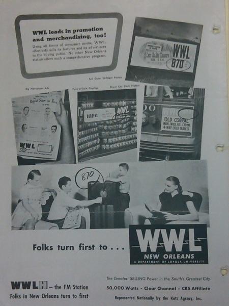
    <summary type="html"><![CDATA[<p><strong><em>WWL, Louisiana's first radio station, started broadcasting in 1922 as a means to raise funds for Loyola University. As a project of a Catholic University, WWL was bound by the rules of the Catholic Church, which forbid commercial practices. WWL found ways around this rule and proceeded to help furnish endowment funds for Loyola University. </em></strong></p><img src="https://neworleanshistorical.org/files/fullsize/8727c6c87c6adcaa76dd415c44714ccb.jpg" alt="WWL Advertising Brochure. Louisiana Research Center Vertical Files, Tulane University. " /><br/><p>Loyola University formed WWL in 1922 for the simple purpose of raising funds. Loyola needed to raise $1.5 million in order to construct six new campus buildings. The call letters, WWL, had no specific meaning to Loyola University, as they were randomly assigned. </p><p>On March 31st, 1922, WWL began the history of broadcasting in Louisiana with its debut at 10:52am. The initial broadcast was a speech given by Father Edward Cummings. Father Cummings devoted part of his speech toward explaining the purpose of the radio station, saying, “We are organizing the radio operators in the state to spread the story of Loyola’s needs. Will you lend your support to our campaign, both by radio and individual effort which will aid us in making Loyola University one of the greatest institutions of learning in the Southland?” Following the speech, WWL played a musical selection by Giuseppe Farate of Tulane’s Newcomb College Faculty, who played an original piano composition.</p><p>Loyola operated WWL as a commercial station, but soon faced issues regarding Canon 142 of the Catholic Church. Canon 142 states “Clerics are forbidden to engage personally or through another in business or to carry on commerce whether for their own benefit of for that of others.” WWL got around this due to the fact that religious magazines and newspapers were allowed to sell advertising in order to cover the costs of operation. By devoting the same amount of time to educational and religious programming and commercial programming, WWL was able to continue its operations. </p><p>However, WWL's main purpose after 1929 was to furnish endowment funds for Loyola University, which held its license. Loyola then formed WWL Development, which was a privately owned holding company run by local businessmen that operated WWL. WWL Development would then compensate Loyola for the revenue the station would bring in. One Loyola president described WWL Development as "a corporation of convenience which saves us Priest-Educators from dealing in the commercial world." </p><p><em><strong><a href="https://neworleanshistorical.org/items/show/1123">For more view the original article</a></strong></em></p>]]></summary>
    <published>2016-03-06T20:52:26+00:00</published>
    <updated>2026-08-24T00:36:24+00:00</updated>
    <link rel="alternate" type="text/html" href="https://neworleanshistorical.org/items/show/1123"/>
    <id>https://neworleanshistorical.org/items/show/1123</id>
    <author>
      <name>Jesse Chicco, Logan Kelley, Daniel Martin, Nicole Schubert,&amp;#32;&amp;amp;&amp;#32;Kathryn O&amp;#039;Dwyer, Editor</name>
    </author>
  </entry>
  <entry>
    <title type="html"><![CDATA[Huey P. Long Bridge: The Kingfish and Public Works Projects in Louisiana]]></title>
    <summary type="html"><![CDATA[<img src="https://neworleanshistorical.org/files/fullsize/a4590635780706325f2587134e118f7c.jpg" alt="&quot;Aerial Photograph Taken from East Bank Looking South.&quot; " /><br/><p>The Huey P. Long Bridge spans the Mississippi River in Jefferson Parish, a few miles upstream of New Orleans itself, and features a central 4.4-mile rail track.  At the time of its construction, the Huey P. Long Bridge was the longest railroad bridge in the world and remains the longest in the US.  Before the bridge was built, the only option for trains to cross the Mississippi River was a clunky ferry system.  The cantilevered steel truss bridge was completed in 1935, just a few months after the assassination of populist governor Huey Long.  The bridge was named in his honor and stands as an homage to his legacy of public works in Louisiana.</p><p>One of the most colorful and controversial figures in Louisiana political history, Huey Long remains complex and controversial for both his political demagoguery and his benevolent populism. Huey P. Long served as governor and senator of Louisiana during the early years of the Great Depression. Long courted previously neglected rural, white voters in order to win the governorship in the 1928 election. He garnered popular support with the promise of numerous construction projects that would provide employment and improved infrastructure, like the Huey P. Long Bridge, throughout the state. During his political reign, Long ordered the construction of thousands of miles of roads, numerous bridges and several municipal buildings, many of which are still in use today.</p><p>Throughout his political career, Long used the patronage system to secure political support, supplying lucrative government positions and contracts to loyal voters and generous political donors. Long proclaimed himself “The Kingfish” as a result of his political style that combined populist appeals with authoritative control over state operations and finances. During the height of his political career, “The Kingfish” maintained a suite at the Fairmont of New Orleans, today’s Roosevelt Hotel, and the Heidelberg Hotel in Baton Rouge.</p><p>Long was elected to the Senate in 1931. While Senator, Long advocated for increased federal funding for state construction projects under his “Share the Wealth” program. “Share the Wealth” garnered so much popular support that it placed pressure on Franklin Delano Roosevelt to create a running platform and national policy that contributed to the formation of Social Security. Originally a supporter and ally of FDR, Long would eventually break with the Democratic President when he found that state politicians like himself would not oversee the dispersal of federal funds from New Deal recovery agencies.</p><p>As Long made a run for the White House in 1935, political tensions in Louisiana began to mount between Long’s supporters and opponents. On September 8, 1935, Carl Weiss, son in law of Long’s political adversary Judge Benjamin Henry Pavy, assassinated Long at the State Capitol Building in Baton Rouge in a wild shootout with Long’s bodyguards. </p><p>Today Long is remembered for the long-lasting public infrastructure projects he supported, including New Orleans’ Charity Hospital, the New Orleans Lakefront Airport, the State Capitol in Baton Rouge, and the State Exposition Hall in Shreveport, along with his flamboyant style and populist approach to politics. Long’s impact on the city of New Orleans remains strongly present as many of the public building created here at the time are still in use.  </p><p><em><strong><a href="https://neworleanshistorical.org/items/show/608">For more (including 7 images) view the original article</a></strong></em></p>]]></summary>
    <published>2013-05-06T21:12:27+00:00</published>
    <updated>2026-08-24T00:39:15+00:00</updated>
    <link rel="alternate" type="text/html" href="https://neworleanshistorical.org/items/show/608"/>
    <id>https://neworleanshistorical.org/items/show/608</id>
    <author>
      <name>Kyle M. Hines&amp;#32;&amp;amp;&amp;#32;Kathryn O&amp;#039;Dwyer</name>
    </author>
  </entry>
  <entry>
    <title type="html"><![CDATA[1984 World&#039;s Fair Gondola (MART) ]]></title>
    <summary type="html"><![CDATA[<img src="https://neworleanshistorical.org/files/fullsize/1d65930c122fbb1eb46ec19175a64be8.jpg" alt="&quot;West Bank Vista&quot;" /><br/><p>The signature attraction of the 1984 Louisiana World Exposition held in New Orleans was MART (Mississippi Aerial River Transit), a $12 million aerial gondola transport system that connected the fair site on the East Bank of the Mississippi River with the West Bank (Old Algiers). For the price of a $3.50 round-trip ticket, fair riders were shuttled 2,500 feet across the Mississippi River in one of 53 six-passenger, teapot-shaped cars strung from cables suspended 320 feet above the river. After the fair, the gondolas briefly became part of the city's mass transit system.</p><p>The gondola project was the long-time dream of Mardi Gras float designer and native Algerian Blaine Kern, who envisioned a "combination thrill ride and practical commuter vehicle" to connect both banks of the river, according to a May 6, 1984, Times-Picayune article. During the 1960s, Kern partnered with architect August Perez III to organize MART, Inc. </p><p>Two decades later, the concept reemerged during plans for the 1984 Louisiana World Exposition (LWE). The system's initial price tag of $8 million was too steep for area banks. Kern pulled his financial backing from the project, but Perez continued with a consortium of investors to form MART/Perez Inc. The World's Fair and the system's projected $10 million in ticket sales during the first six months of operation gave impetus to the lagging endeavor. Perez found a French bank, Banque de L'Union Européenne of Paris, willing to underwrite the project. Though new to the Louisiana market, the bank was quite familiar with gondola systems. Upon the approval of a 60-year city franchise, the gondolas became a reality.</p><p>Construction of the custom-built aerial gondola system began on September 29, 1983, after a host of clearances from sixty-four state, city, and river agencies that shared jurisdiction over the project. Pomagalski S.A., of Grenoble, France supplied the equipment while MART/Perez Inc. constructed the gondola system. </p><p>To operate in a generally flat city, two 360 foot steel cable towers spaced 2169 feet apart were built to anchor the aerial gondola system. They were designed at a 20-degree tilt toward the river in order to protect the integrity of the Mississippi River levees. The gondola system included eight safety switches and a unique rescue vehicle known as a Pomabus; this was a self-propelled cart that could traverse a stopped cable and enclose a gondola so passengers could be removed and brought back to the terminal. Evidence suggests that the Pomabus never had to be used.</p><p>MART ranked with Disney's Space Mountain ride as the two best thrill rides in America during the six months of the exposition.  Despite its popularity, the gondola struggled to attract the anticipated 3 million riders -- mainly because of the fair's low attendance. The fate of the gondolas was tied closely to the fair's success -- or lack of success. Riders either had to buy a fair ticket or possess a season passport before they could purchase a gondola ticket.</p><p>After the fair closed, the gondola system was promoted as a unique commuter system.  MART officials hoped that West Bankers would ride the gondola daily to and from the east bank, especially to the Central Business District.  A commuter could purchase a $25 unlimited (per month) ride ticket or a $50 ticket; the latter included daily parking at the lot adjacent to the West Bank terminal. West Bankers did not embrace the concept nor did the residents of old Algiers welcome the additional automobile traffic during the fair. Four months after the bankrupt LWE closed, its signature attraction ceased operation permanently.</p><p>While legal battles concerning loan payments, property rights, and ownership ensued, the last remaining structure of the fair remained idle. The New Orleans Dock Board began the process of having the entire system dismantled. In 1992, the passenger cars were sold, and in 1994 the US Coast Guard ordered the removal of the 360 foot steel towers and their cables. MART did not become a legendary landmark of the 1984 World's Fair, but for thousands of fairgoers it provided a lifelong memory.</p><p><em><strong><a href="https://neworleanshistorical.org/items/show/563">For more (including 5 images) view the original article</a></strong></em></p>]]></summary>
    <published>2013-03-09T01:55:52+00:00</published>
    <updated>2026-08-24T00:39:15+00:00</updated>
    <link rel="alternate" type="text/html" href="https://neworleanshistorical.org/items/show/563"/>
    <id>https://neworleanshistorical.org/items/show/563</id>
    <author>
      <name>Frank Straughan</name>
    </author>
  </entry>
  <entry>
    <title type="html"><![CDATA[1984 World&#039;s Fair Monorail]]></title>
    <summary type="html"><![CDATA[<img src="https://neworleanshistorical.org/files/fullsize/9d11a206e6b9648d0c7f1a4d69eb519b.jpg" alt="LWE monorail passes over the space shuttle Enterprise" /><br/><p>When planning the 1984 Louisiana World Exposition (LWE), fair and city officials decided to build a monorail system. This project had two objectives. First, it was intended to move many visitors so as to limit traffic congestion in the Warehouse and Downtown districts directly adjacent to the fair. Second, this advanced transportation infrastructure was supposed to stay in New Orleans as a tribute to modernity. Mayor Ernest “Dutch” Morial had hoped to build a line down the middle of Poydras Street to connect the new Convention Center to the Superdome. The city wanted to repeat the successful conversion of the Seattle World’s Fair monorail into permanent transit infrastructure.</p><p>When the Reagan administration refused to fund the monorail, the city decided to build it on the 80-acre riverfront site of the fair. Six companies bid, and the contract was awarded to Universal Mobility Inc., a Salt-Lake City company which had built 8 other monorail systems in North America. New Orleans’ system was a $15 million, 1.4 mile rubber-tired monorail based on the Straddle - Steel Box Beam technology. Introduced in the 1960s, this technology is still used. </p><p>Three elevated stations were designed by Charles Sanders of Perez and Associates Architecture Company. The New York Times advised that “the silent, elegant monorail will loop everywhere, diving at points into buildings.” The ten car, 146 passenger monorail circled the Exposition counterclockwise. It reached speeds of 10 miles per hour and took 12 minutes to complete the trip. One of the transit stations hosted a local television news broadcast center, which allowed live coverage of the fair. </p><p>Several plans were considered for the subsequent use of the monorail system. Allan Eskew, the main architect of the fair, proposed to give it to Audubon Park or City Park to move the public within their grounds. Later, the Regional Transit Authority (RTA) announced that that they were interested in purchasing the monorail to install it in the center of Poydras Street, as previously envisioned by the Mayor Morial administration. The federal money that RTA had traditionally used to buy transit equipment could not be used to buy monorail systems, and the RTA failed to raise private money to fund the project.</p><p>Unfortunately, the fair did not attract the 11 million visitors that the LWE officials had expected, so the fair left a $102 million debt. The LWE had to file for bankruptcy and could not pay its contractors. Universal Mobility sued Petr Spurney and Floyd Lewis, respectively president and chairman of the Louisiana World Exposition. In a 1985 hearing, the US District Judge ruled that LWE officials were not personally responsible for the debts. The assets of the LWE were auctioned in 1985, including the monorail and its three elevated stations.</p><p><em><strong><a href="https://neworleanshistorical.org/items/show/541">For more (including 4 images) view the original article</a></strong></em></p>]]></summary>
    <published>2013-02-28T00:49:27+00:00</published>
    <updated>2026-07-15T16:20:34+00:00</updated>
    <link rel="alternate" type="text/html" href="https://neworleanshistorical.org/items/show/541"/>
    <id>https://neworleanshistorical.org/items/show/541</id>
    <author>
      <name>Romain Cheynet</name>
    </author>
  </entry>
  <entry>
    <title type="html"><![CDATA[Early Ferry Service across the Mississippi River]]></title>
    <summary type="html"><![CDATA[<img src="https://neworleanshistorical.org/files/fullsize/bbe63ca731b98a32dfd758c178ac51dc.jpg" alt="2nd District Ferry (Canal Street Ferry), 1867" /><br/><p>Since the founding of New Orleans in 1718, the Mississippi River proved crucial in the city's development as a colonial French and Spanish port. Crossing the river was essential from the outset. The first enslaved Africans brought to the colony during the John Law Company period (1717-1731) were housed directly across from the settlement on the West Bank in what is now Algiers Point. Smallpox patients and others suffering from contagious diseases were quarantined on what was then known as the "Left Bank."</p><p>Ferries and skiffs moved goods and people across the river to Algiers. In the early 1800s, city officials awarded steam ferry service contracts to convey passengers and goods on a regular schedule between the two banks. The first regularly scheduled ferry service between Canal Street and Algiers was established in 1827. </p><p>Several other public ferry crossings developed as the city spread up- and downriver from its original site. Six ferries served the New Orleans area in the 1930's. Three other ferries continue to serve the metropolitan area today: Chalmette to Lower Coast Algiers; Gretna to Canal Street; and East to West Point-a-la Hache.</p><p><em><strong><a href="https://neworleanshistorical.org/items/show/290">For more (including 9 images) view the original article</a></strong></em></p>]]></summary>
    <published>2012-07-03T01:43:41+00:00</published>
    <updated>2026-07-15T16:20:35+00:00</updated>
    <link rel="alternate" type="text/html" href="https://neworleanshistorical.org/items/show/290"/>
    <id>https://neworleanshistorical.org/items/show/290</id>
    <author>
      <name>Vincent Petreikis&amp;#32;&amp;amp;&amp;#32;University of New Orleans History Department</name>
    </author>
  </entry>
  <entry>
    <title type="html"><![CDATA[New Orleans &amp; Carrollton Rail Road]]></title>
    <summary type="html"><![CDATA[<img src="https://neworleanshistorical.org/files/fullsize/2adbee52fa0495d8a9009a2a4f8b6464.jpg" alt="Rendering of an Early Carrollton Streetcar" /><br/><p>The New Orleans and Carrollton Railroad began in 1835 as a mule and horse driven line that ran from the city of Carrollton to Lee Circle. The line served to bring commuters to the city of New Orleans from the town of Carrollton, which was the first real bedroom suburb of New Orleans. The town of Carrollton was incorporated in 1845, and officially annexed in 1874. As the community expanded from a destination for wealthy new Orleanians to its various attractions (like the Carrollton gardens and the Carrollton hotel) to a true suburb, the rail line evolved to accommodate the commuter crowds. </p><p>After expanding their lines through the absorption of the Jefferson and Lake Ponchatrain Rail Company, the next major upgrade to the line was the switch to electricity. Former confederate general P.G.T. Beauregard took over the job of superintendent in late 1860 and began to experiment with new types of cars, including cable, and eventually deciding to upgrade to electric cars. </p><p>The New Orleans & Carrollton Rail Road, which still runs this day along St. Charles Avenue, was an import an part of the urban development on New Orleans, bringing commuters from the first suburb of new orleans to the city.</p><p><em><strong><a href="https://neworleanshistorical.org/items/show/282">For more (including 4 images) view the original article</a></strong></em></p>]]></summary>
    <published>2012-06-19T00:41:11+00:00</published>
    <updated>2026-07-15T16:20:35+00:00</updated>
    <link rel="alternate" type="text/html" href="https://neworleanshistorical.org/items/show/282"/>
    <id>https://neworleanshistorical.org/items/show/282</id>
    <author>
      <name>Samuel Katz</name>
    </author>
  </entry>
  <entry>
    <title type="html"><![CDATA[Government and States Building and Exhibits at the 1884 Cotton Centennial Exposition]]></title>
    <summary type="html"><![CDATA[<img src="https://neworleanshistorical.org/files/fullsize/54e3b2b5ced45f4e588e3ef618c80c1d.jpg" alt="Government and States Building under construction, 1884" /><br/><p>To the right of where you sit was the Government and States Building, still partially under construction when the exposition opened. By January and February, 1885, however, most exhibits were in place. Government departments clustered in the center, states by region encircled these, and on the balcony were special department: the Education Department, the Woman's Department, and the first-ever Colored Department. In an increasingly industrial world, these departments sought to prove the worthiness of their participants.  </p><p>An onion-domed working post office operated every day as part of federal exhibits. States created fanciful displays of their natural and manufactured resources.</p><p>Life-saving demonstrations took place daily on this lake next to the Government and States Building. Other daily attractions were designed to bring visitors to the grounds: fireworks, balloon ascensions, parades, musical concerts, and special days to honor various states, groups, and ethnicities. </p><p>In addition to the spectacle of electric lights and elevators, telephones were new as were a host of products and machinery that awed the crowds.</p><p><em><strong><a href="https://neworleanshistorical.org/items/show/197">For more (including 10 images) view the original article</a></strong></em></p>]]></summary>
    <published>2012-05-07T23:35:38+00:00</published>
    <updated>2026-07-15T16:20:35+00:00</updated>
    <link rel="alternate" type="text/html" href="https://neworleanshistorical.org/items/show/197"/>
    <id>https://neworleanshistorical.org/items/show/197</id>
    <author>
      <name>Miki Pfeffer</name>
    </author>
  </entry>
  <entry>
    <title type="html"><![CDATA[Memories of the 1884 Cotton Centennial Exposition]]></title>
    <summary type="html"><![CDATA[<img src="https://neworleanshistorical.org/files/fullsize/6072d52710f01975018daa480374bb9f.jpg" alt="Main entrance to the exposition" /><br/><p>Imagine yourself in a mule-drawn streetcar or private carriage being transported to Exposition grounds. Hear the hooves on a shell road constructed for the occasion. You arrive at this Main Entrance. Its architecture reflects that of the gigantic Renaissance-styled Main Building behind it. You pay 50 cents to enter, about half the cost of a rental room for the day.</p><p>Mississippi architect Gustav M. Torgerson designed the Main Building's exterior to echo the towers, arches, and turrets of the Louvre Museum in Paris. The interior exhibit halls had few obstructions, and the huge Music Hall at the building's center could seat 11,000 people in the audience and 600 on the stage. Long rows of skylights invited in natural light over miles of aisles where manufactured goods confirmed the advance of industrialization. For the first time at a World's Fair, elevators took visitors to second floors and electric lights illuminated the structures and the grounds and allowed the exposition to remain open until 9 p.m. </p><p>Picture the great fanfare with which the event opened on December 16, 1884. Officials and dignitaries arrived on flag-draped steamboats and processed through throngs of well-wishers to this Main Building and Music Hall. After celebratory speeches, prayers, and poems, President Chester A. Arthur finally clicked the button from Washington City (D. C.). The giant Corliss engine roared power throughout the facility, and the World's Industrial and Cotton Centennial Exposition was officially under way. Only the Music Hall's gigantic Pilcher Brothers organ could compete with the noise of the motors; the building was never quiet again. The vast space has been used for numerous celebratory events, such as when Rex, King of Carnival, greeted his subjects the day before Mardi Gras, on Lundi Gras February 16, 1885.</p><p>Although few exhibits were in place on opening day, fantastic displays rose over time, and heavy industrial and farming equipment caught the attention of visitors--  including a row of the latest steam locomotives. Imagine the days you could spend roaming aisle to aisle, your head swimming with new products and inventions.</p><p><em><strong><a href="https://neworleanshistorical.org/items/show/196">For more (including 9 images) view the original article</a></strong></em></p>]]></summary>
    <published>2012-05-07T20:08:00+00:00</published>
    <updated>2026-07-15T16:20:35+00:00</updated>
    <link rel="alternate" type="text/html" href="https://neworleanshistorical.org/items/show/196"/>
    <id>https://neworleanshistorical.org/items/show/196</id>
    <author>
      <name>Miki Pfeffer</name>
    </author>
  </entry>
  <entry>
    <title type="html"><![CDATA[Former Entrance to the 1884 Cotton Centennial Exhibition on Prytania]]></title>
    <summary type="html"><![CDATA[<img src="https://neworleanshistorical.org/files/fullsize/fe05e123ec0a0a66295fbf021db85ab2.jpg" alt="Along the water&#039;s edge" /><br/><p>Cross over to the path along the side of the park that is Exposition Boulevard. Walk along and admire the houses on your way to Prytania Street, the main entrance to the fair in 1884.</p><p>In post-reconstruction New Orleans, the celebrated event, officially known as the World's Industrial and Cotton Centennial Exposition, commemorated one hundred years of the export of cotton. Proponents of a "New South" movement strategically designed it to convince northern investors that the region had put aside sectional and racial animosities and was eager for reunion and industrialization. If successful, New Orleans might recapture some of its former glory and economic power. With a million-dollar loan from Congress and 247 acres of acquired land (then Upper City Park), developers built huge structures to house a spectacular array of foreign and domestic exhibits ranging from the humblest spool of thread to the grandest railroad locomotive. </p><p>Although the Cotton Centennial Exposition was neither a financial nor a political success, it did leave significant legacies in the city. These include the further development of what later became Audubon Park and the residential area surrounding it, especially the handsome residential boulevard beside it. For the exposition purposes, shells paved this road to the main entrance.</p><p>When you arrive at Prytania Street and Exposition Boulevard, note that there is still a hint of a formal entrance as the path opens outward from Prytania. Re-cross the paths and relax on a bench or in the gazebo near the lagoon's edge as you imagine the 1884 Cotton Centennial Expo, beginning with the ground plan for the entire undertaking.</p><p><em><strong><a href="https://neworleanshistorical.org/items/show/194">For more (including 5 images) view the original article</a></strong></em></p>]]></summary>
    <published>2012-05-07T04:26:08+00:00</published>
    <updated>2026-07-15T16:20:35+00:00</updated>
    <link rel="alternate" type="text/html" href="https://neworleanshistorical.org/items/show/194"/>
    <id>https://neworleanshistorical.org/items/show/194</id>
    <author>
      <name>Miki Pfeffer</name>
    </author>
  </entry>
  <entry>
    <title type="html"><![CDATA[From the Water&#039;s Edge: The 1884 Cotton Centennial Exposition]]></title>
    <summary type="html"><![CDATA[<img src="https://neworleanshistorical.org/files/fullsize/1af075f05f0c0ffb4e3666b97dbde630.jpg" alt="Across the Olmstead lagoon" /><br/><p>In the eighteenth century, working sugar plantations existed on this land. They faced the Mississippi River, which is straight ahead about a half mile. Pierre Foucher planted long alleys of live oak trees to frame his house. His neighbor Etienne de Boré, the city's first mayor, helped simplify and commercialize the granulation process of sugar that made the crop more profitable. The planters' link to the social and economic world was the river. Where you stand was the back section of their plantations. </p><p>By the nineteenth century, the land hosted other links to a changing world. At the start of the Civil War, locals gathered on the Foucher property to watch Confederate soldiers train in Camp Lewis. By 1863, Union General Benjamin Butler took control of the camp and replaced it with a Union hospital. Immediately after the Civil War, African-American troops known as "Buffalo Soldiers" trained here. In 1871, during Reconstruction, the city of New Orleans bought the property for $800,000 and created a Park Commission. Yet, hard times meant little money or impetus to develop the land.</p><p>As the city struggled to lift itself out of financial doldrums, politicians and businessmen mounted a spectacular World's Industrial and Cotton Centennial Exposition in 1884. They hoped that international attention might help New Orleans reclaim its former glory and economic prowess as the leader of a "New South." What was then a barren Upper City Park became landscaped exposition grounds with huge (but temporary) buildings. When the fair closed, all the buildings were sold for scrap except Horticultural Hall, which stood at the river end of Foucher's double stand of graceful oaks. </p><p>Once the structures were removed, the Park Commission engaged the Olmstead firm (of Central Park fame) to prepare a master plan that would use Horticultural Hall and the moss-draped trees as centerpieces. Over three decades, the park was a work in progress, plagued with delays and changes. The lagoon before you–park wide and running along the entire downtown side of the grounds–was by then a signature Olmstead feature.</p><p>Had you stood on this spot in 1884 and looked across to the left, you would have seen the Government and States Building; looking straight ahead, the enormous Main Building loomed. The wooden structure covered 33 acres and was larger than the present-day United States Pentagon. Beyond the Main Building, a small octagon-shaped Mexican Building stood.  Slightly behind you and to the right along St. Charles Avenue were livestock yards. The scent of competing farm animals would probably have wafted across this spot.</p><p><em><strong><a href="https://neworleanshistorical.org/items/show/192">For more (including 4 images) view the original article</a></strong></em></p>]]></summary>
    <published>2012-05-07T03:00:13+00:00</published>
    <updated>2026-07-15T16:20:35+00:00</updated>
    <link rel="alternate" type="text/html" href="https://neworleanshistorical.org/items/show/192"/>
    <id>https://neworleanshistorical.org/items/show/192</id>
    <author>
      <name>Miki Pfeffer</name>
    </author>
  </entry>
  <entry>
    <title type="html"><![CDATA[New Canal Coast Guard Station]]></title>
    <summary type="html"><![CDATA[<img src="https://neworleanshistorical.org/files/fullsize/5abe9ec8804ec7196e9d132700bcfae9.jpg" alt="First Canal Lighthouse " /><br/><p>The US Coast Guard's lakefront station was once located at Spanish Fort. By the 1960s, the structure at Spanish Fort had sustained damage from many hurricanes and was in disrepair. The station then moved to the site of the New Canal Lighthouse at the head of the New Basin Canal to monitor boating activity in Lake Ponchartrain.</p><p>On October 1, 1987, the Patrol Boats Division based on the Industrial Canal was combined with New Canal Station. This established the US Coast Guard Station New Orleans at the New Canal site. </p><p>The New Canal Coast Guard was responsible for Lake Pontchartrain, Lake Borgne, Lake Maurepas, the Pearl River, the Mississippi River Gulf Outlet mile 46, the Mississippi River from mile 46 to mile 232, the Intracoastal Waterway from Pearl River to Bayou Lafourche, and all tributaries and surrounding bayous. </p><p>On November 14, 2001, USCG Station New Orleans moved from the New Canal Lighthouse to a facility one-and-a-half miles away in Bucktown, Metairie.</p><p><em><strong><a href="https://neworleanshistorical.org/items/show/139">For more (including 3 images) view the original article</a></strong></em></p>]]></summary>
    <published>2012-04-25T21:52:51+00:00</published>
    <updated>2026-07-15T16:20:35+00:00</updated>
    <link rel="alternate" type="text/html" href="https://neworleanshistorical.org/items/show/139"/>
    <id>https://neworleanshistorical.org/items/show/139</id>
    <author>
      <name>Patrick Stephen</name>
    </author>
  </entry>
  <entry>
    <title type="html"><![CDATA[New Canal Lighthouse]]></title>
    <summary type="html"><![CDATA[<img src="https://neworleanshistorical.org/files/fullsize/fe978842d0548cf14b45f6aec59609ed.jpg" alt="New Basin Lighthouse, 1950s" /><br/><p>In the 1830s, Irish and German immigrants dug the New Basin Canal as a link between New Orleans and Lake Pontchartrain. The lake end of the canal featured the New Canal Lighthouse, originally an octagonal, wooden tower resting on pilings driven into the lake bottom. Built by Francis D. Gott in 1838 for $4,500, the tower's lower timbers rotted within four years, causing it to lean.</p><p>Originally, the lighthouse stood approximately 1,000 feet offshore. Landfill projects in the early 1900s slowly brought the shore closer to the lighthouse, creating what is now Lakefront Drive. After the original lighthouse was torn down, a second square-shaped, one-story iron piling was completed in 1855.</p><p>During the American Civil War, the Confederate forces kept the lighthouse active until New Orleans fell to Union forces in April 1862.  </p><p>The lighthouse remained active from the end of the Civil War in 1865 until August 2005, when Hurricane Katrina damaged the lighthouse beyond repair. In 2007, the Lake Pontchartrain Basin Foundation dismantled the remains and salvaged as many historic materials as possible.</p><p>The lighthouse re-opened in 2013 as the New Canal Lighthouse Museum and Education Center. The lighthouse contains exhibits on the history, ecology, and preservation of the lake and lighthouse, as well as views of the lake from the outdoor deck. At night, the lighthouse's beacon is still in operation to guide boats passing through the lake.</p><p><em><strong><a href="https://neworleanshistorical.org/items/show/138">For more (including 4 images) view the original article</a></strong></em></p>]]></summary>
    <published>2012-04-25T21:47:50+00:00</published>
    <updated>2026-07-15T16:20:35+00:00</updated>
    <link rel="alternate" type="text/html" href="https://neworleanshistorical.org/items/show/138"/>
    <id>https://neworleanshistorical.org/items/show/138</id>
    <author>
      <name>Patrick Stephen</name>
    </author>
  </entry>
  <entry>
    <title type="html"><![CDATA[Mules and Modernization]]></title>
    <summary type="html"><![CDATA[<img src="https://neworleanshistorical.org/files/fullsize/1232255e42d7fbbf8fb08a4ca8a3e489.jpg" alt="Cartoon Promoting Electrification" /><br/><p>Facing Jackson Square, one should see a line of mules and their drivers ready to take visitors on a trip around the French Quarter. Now a tourist attraction, these animals played a vital role for New Orleans before the advent of motorized vehicles. Heartier than horses, mules could endure this hot and humid climate. New Orleanians put them to work hauling garbage trucks, pulling streetcars, and even towing the Mardi Gras parade floats.</p><p>Near the end of the 19th century, New Orleans residents began to notice that many of the city's mules were overworked and malnourished. These emaciated animals struggled to pull their cars and, in some cases, fell down dead in the street still harnessed. In 1888, concerned Louisianans formed a local chapter of the Society for the Prevention of Cruelty to Animals (LASPCA) in order to fight for better treatment of the city's beasts of burden. The LASPCA, along with the New Orleans Police Department and local newspapers, raised awareness and ensured improved conditions for the mules. The organization may also have hastened the arrival of the electric streetcar. New Orleans, satisfied with mule-drawn cars, had been slow to make the change to electric cars, though the technology had been available by the mid-1880s. But pressure from the LASPCA as well as economic incentive (these electric streetcars were much more cost efficient) ensured that by 1893, New Orleans was welcoming electricity and retiring its mules.</p><p>Because the LASPCA was established in order to aid mules, whereas in other cities the mistreatment of domestic animals like dogs and cats was the impetus, many New Orleans residents have confidence that the carriage mules are well treated. And this is primarily true; however, recently controversy has erupted over this same issue once again. In December 2011, one of these mules died while pulling a carriage along Bourbon Street. Protestors responded with the same passion of a century before. As it turned outs, this carriage driver was operating without a license. The LASPCA responded by assuring all who might be concerned that the organization works with the carriage companies directly and ensures that the horses are given the "best care possible."</p><p>To move to the next location and learn about how mosquitoes have affected the New Orleans population, cross Decatur St. Be sure to look out for traffic. Head into Jackson Square and stop when you reach the fountain at the far end of the park, near St. Louis Cathedral.</p><p><em><strong><a href="https://neworleanshistorical.org/items/show/137">For more (including 6 images&#32;&amp;&#32;1 video) view the original article</a></strong></em></p>]]></summary>
    <published>2012-04-25T19:49:35+00:00</published>
    <updated>2026-08-24T00:44:19+00:00</updated>
    <link rel="alternate" type="text/html" href="https://neworleanshistorical.org/items/show/137"/>
    <id>https://neworleanshistorical.org/items/show/137</id>
    <author>
      <name>Alison Laurence</name>
    </author>
  </entry>
  <entry>
    <title type="html"><![CDATA[Mosquitoes and Yellow Fever]]></title>
    <summary type="html"><![CDATA[<img src="https://neworleanshistorical.org/files/fullsize/dd34aebf5b4938c9b25e35551e0047b0.jpg" alt="Yellow Fever Quarantine Camp, " /><br/><p>As you stand in front of the fountain in Jackson Square or walk through the French Quarter peering into courtyards and hearing the faint trickle and splash of a fountain, think about the bugs that these water features attract. Mosquitoes have been plaguing New Orleanians since the first colonists arrived in the 18th century. In addition to biting our ankles and leaving behind itchy welts, mosquitoes spread diseases like Yellow Fever. </p><p>It took a long time to combat this disease because people did not understand what exactly caused the fever or how it spread. After the particularly deadly epidemic of 1853, in which 7,849 people died, the city strove to find ways to counter Yellow Fever. One method included burning tar, which was supposed to purify the air. The municipal government also ordered the city's cannons to be fired, supposing that the vibrations would shake the disease out of the air.</p><p>The city's swamp setting contributed to the extremely high fever fatalities. Since portions of New Orleans are below sea-level, clean drinking water has always been an issue. Wells are not an option, as digging even a few feet into the ground will hit bogs. So residents relied on cisterns, massive wood or iron cylinders that were open on the top for collecting rainwater, to provide clean water. Of course, mosquitoes are attracted to standing water and lay their eggs in the stagnant pools.</p><p>The last Yellow Fever epidemic in the United States struck New Orleans in 1905, which was the same year that doctors working at Walter Reed Hospital discovered the link between mosquitoes and Yellow Fever. With an understanding of the disease, New Orleans officials were able to fight it, primarily by ordering that all cisterns be covered.</p><p>The city's fog trucks drive slowly down the streets of New Orleans, spraying pesticides into the air in order to kill the bugs and their eggs. The agency also uses an airplane for marsh areas.  So while you pause at this fountain, keep in mind the tens of thousands of New Orleanians for whom water such as this proved deadly.</p><p>To find out about how termites have impacted the very foundations of this city, proceed to the corner of Chartres and Toulouse. Simply exit Jackson Square toward St. Louis Cathedral and immediately turn left. Follow Chartres St. for a block and a half. As you walk, take note of the evenly spaced silver circles that dot the sidewalks of the French Quarter.</p><p><em><strong><a href="https://neworleanshistorical.org/items/show/132">For more (including 6 images) view the original article</a></strong></em></p>]]></summary>
    <published>2012-04-25T18:45:55+00:00</published>
    <updated>2026-07-15T16:20:35+00:00</updated>
    <link rel="alternate" type="text/html" href="https://neworleanshistorical.org/items/show/132"/>
    <id>https://neworleanshistorical.org/items/show/132</id>
    <author>
      <name>Alison Laurence&amp;#32;&amp;amp;&amp;#32;Sarah Waits</name>
    </author>
  </entry>
</feed>